
File:BeitHanina9861-labels.png

Size of this preview: 800 × 600 pixels. Other resolutions: 320 × 240 pixels | 640 × 480 pixels | 1,024 × 768 pixels | 1,280 × 960 pixels | 2,560 × 1,920 pixels | 2,848 × 2,136 pixels.
Original file (2,848 × 2,136 pixels, file size: 10.78 MB, MIME type: image/png)
| This is a file from the Wikimedia Commons. Information from its description page there is shown below. Commons is a freely licensed media file repository. You can help. |
Summary
| Description |
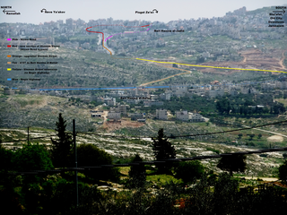
English: In the center is the old village of Beit Hanina (Beit Hanina al-Balad) as viewed eastward from the Tomb of Samuel. Above is the new village of Beit Hanina (Beit Hanina al-Jadid), presently a neighborhood of Jerusalem. Horizontally in the center (Blue) are walls along Begin Expressway which also serve as part of Israel's separation barrier. The large boulevard at the top (Red, Orange) is Abdel Hamid Shomaan Street, part of the new Jerusalem Road 20. At the top (Pink) is the old Hizma Road. The (Red) new Shoman Street bypasses it on the way to Pisgat Ze'ev. On the right (Yellow) is the Shoman Street extension to Begin Highway (under construction at time of photo). The continuation (Tan) of Shoman Street (4197) to Beit Hanina al-Balad includes an agricultural gate under Begin Highway. (Dotted lines depict road segments obscured behind buildings or terrain.) FOR A VERSION OF THE PHOTO WITHOUT LABELS: File:BeitHanina9861.JPG |
| Date | |
| Source | commons.wikimedia |
| Author | יעקב, Labels added by Atefrat |
| Object location | | View this and other nearby images on: OpenStreetMap |
|---|
| Camera location | | View this and other nearby images on: OpenStreetMap |
|---|
Licensing
This file is licensed under the Creative Commons Attribution-Share Alike 3.0 Unported license.
- You are free:
- to share – to copy, distribute and transmit the work
- to remix – to adapt the work
- Under the following conditions:
- attribution – You must give appropriate credit, provide a link to the license, and indicate if changes were made. You may do so in any reasonable manner, but not in any way that suggests the licensor endorses you or your use.
- share alike – If you remix, transform, or build upon the material, you must distribute your contributions under the same or compatible license as the original.
File history
Click on a date/time to view the file as it appeared at that time.
| Date/Time | Thumbnail | Dimensions | User | Comment | |
|---|---|---|---|---|---|
| current | 08:11, 6 June 2013 | | 2,848 × 2,136 (10.78 MB) | Atefrat | color |
| 07:28, 6 June 2013 |  | 2,848 × 2,136 (10.78 MB) | Atefrat | labels | |
| 06:43, 6 June 2013 |  | 2,848 × 2,136 (10.79 MB) | Atefrat | User created page with UploadWizard |
File usage
The following pages on the English Wikipedia use this file (pages on other projects are not listed):
Global file usage
The following other wikis use this file: