
File:Akita Kazuno-gun.png
Akita_Kazuno-gun.png (236 × 294 pixels, file size: 5 KB, MIME type: image/png)
| This is a file from the Wikimedia Commons. Information from its description page there is shown below. Commons is a freely licensed media file repository. You can help. |
Summary
| Description |
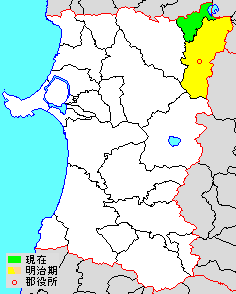
日本語: 鹿角郡秋田県鹿角郡、市町村境界図
English: en:Kazuno District, Akita Map of Kazuno District, Akita, Japan |
||
| Source | File:Japan map.png | ||
| Author |
|
||
| Permission (Reusing this file) |
|
Licensing

|
Permission is granted to copy, distribute and/or modify this document under the terms of the GNU Free Documentation License, Version 1.2 or any later version published by the Free Software Foundation; with no Invariant Sections, no Front-Cover Texts, and no Back-Cover Texts. A copy of the license is included in the section entitled GNU Free Documentation License. |
- You are free:
- to share – to copy, distribute and transmit the work
- to remix – to adapt the work
- Under the following conditions:
- attribution – You must give appropriate credit, provide a link to the license, and indicate if changes were made. You may do so in any reasonable manner, but not in any way that suggests the licensor endorses you or your use.
- share alike – If you remix, transform, or build upon the material, you must distribute your contributions under the same or compatible license as the original.
Original upload log
The original description page is/was here. All following user names refer to ja.wikipedia.
- 2012-11-27 15:01 検見川町 236 × 294 (5 kilobytes) 秋田県鹿角郡、市町村境界図 {{Japan map}}
File history
Click on a date/time to view the file as it appeared at that time.
| Date/Time | Thumbnail | Dimensions | User | Comment | |
|---|---|---|---|---|---|
| current | 02:55, 29 August 2013 | | 236 × 294 (5 KB) | MChew | {{Information |Description=Map of Kazuno District, Akita, Japan |Source={{transferred from|ja.wikipedia|}} |Date={{original upload date|2012-11-27 }} |Author={{original uploader|検見川町|wikipedia|ja}} |Permission= |other_versions= }} == {{int:lic... |
| 15:01, 27 November 2012 |  | 236 × 294 (5 KB) | 検見川町 | 配色変更、郡役所の位置を反映。 | |
| 07:06, 22 September 2012 |  | 264 × 294 (5 KB) | 検見川町 | 平成の大合併と明治期の郡域を反映。 | |
| 04:05, 21 September 2004 |  | 264 × 294 (5 KB) | 赤鉛筆 | 秋田県鹿角郡、市町村境界図 |
File usage
Global file usage
The following other wikis use this file:
- Usage on ceb.wikipedia.org
- Usage on fa.wikipedia.org
- Usage on id.wikipedia.org
- Usage on ja.wikipedia.org
- Usage on kk.wikipedia.org
- Usage on ko.wikipedia.org
- Usage on ru.wikipedia.org
- Usage on th.wikipedia.org