
File:A dip in the headland - geograph.org.uk - 749720.jpg
No higher resolution available.
A_dip_in_the_headland_-_geograph.org.uk_-_749720.jpg (640 × 480 pixels, file size: 191 KB, MIME type: image/jpeg)
| This is a file from the Wikimedia Commons. Information from its description page there is shown below. Commons is a freely licensed media file repository. You can help. |
Summary
| Description |
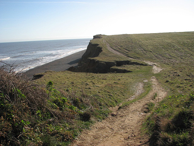
English: A dip in the headland At their lowest point (seen in mid-distance) the eroded cliffs are only a few metres high and access onto the shingle beach is possible from here. Erosion is evident all along the coastline and the track denoting the Norfolk Coast Path/Peddars Way is slowly falling into the sea; the waves of the North Sea undermine the cliffs and cause large sections to tumble onto the beaches. About 2.5 metres (in some sections up to 5 metres) of headland is lost every year. |
| Date | Taken on 3 April 2008 |
| Source | From geograph.org.uk |
| Author | Evelyn Simak |
| Attribution (required by the license) | Evelyn Simak / A dip in the headland / |
| Camera location | | View this and other nearby images on: OpenStreetMap |
|---|
_heading:90.00&language=en)
| Object location | | View this and other nearby images on: OpenStreetMap |
|---|
_heading:90.00&language=en)
Licensing

|
This image was taken from the Geograph project collection. See this photograph's page on the Geograph website for the photographer's contact details. The copyright on this image is owned by Evelyn Simak and is licensed for reuse under the Creative Commons Attribution-ShareAlike 2.0 license.
|
This file is licensed under the Creative Commons Attribution-Share Alike 2.0 Generic license.
Attribution: Evelyn Simak
- You are free:
- to share – to copy, distribute and transmit the work
- to remix – to adapt the work
- Under the following conditions:
- attribution – You must give appropriate credit, provide a link to the license, and indicate if changes were made. You may do so in any reasonable manner, but not in any way that suggests the licensor endorses you or your use.
- share alike – If you remix, transform, or build upon the material, you must distribute your contributions under the same or compatible license as the original.
File history
Click on a date/time to view the file as it appeared at that time.
| Date/Time | Thumbnail | Dimensions | User | Comment | |
|---|---|---|---|---|---|
| current | 10:37, 19 February 2011 | | 640 × 480 (191 KB) | GeographBot | == {{int:filedesc}} == {{Information |description={{en|1=A dip in the headland At their lowest point (seen in mid-distance) the eroded cliffs are only a few metres high and access onto the shingle beach is possible from here. Erosion is evident all along |
File usage
The following pages on the English Wikipedia use this file (pages on other projects are not listed):