
File:2021 Cambridgeshire and Peterborough mayoral second round results.svg

Size of this PNG preview of this SVG file: 512 × 576 pixels. Other resolutions: 213 × 240 pixels | 427 × 480 pixels | 683 × 768 pixels | 910 × 1,024 pixels | 1,820 × 2,048 pixels.
Original file (SVG file, nominally 512 × 576 pixels, file size: 673 KB)
| This is a file from the Wikimedia Commons. Information from its description page there is shown below. Commons is a freely licensed media file repository. You can help. |
Summary
| Description |
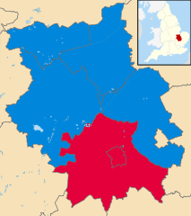
English: Second-rounds results of the 2021 Cambridgeshire and Peterborough mayoral election
Colours: Labour
Conservative |
| Date | |
| Source |
Original: w:File:Peterborough UK locator map.svg Ordnance Survey OpenData [results]
|
| Author | User:Ralbegen, original map: Nilfanion, created using Ordnance Survey data |
Licensing
This file is licensed under the Creative Commons Attribution-Share Alike 3.0 Unported license.
- You are free:
- to share – to copy, distribute and transmit the work
- to remix – to adapt the work
- Under the following conditions:
- attribution – You must give appropriate credit, provide a link to the license, and indicate if changes were made. You may do so in any reasonable manner, but not in any way that suggests the licensor endorses you or your use.
- share alike – If you remix, transform, or build upon the material, you must distribute your contributions under the same or compatible license as the original.
File history
Click on a date/time to view the file as it appeared at that time.
| Date/Time | Thumbnail | Dimensions | User | Comment | |
|---|---|---|---|---|---|
| current | 20:46, 29 May 2021 | | 512 × 576 (673 KB) | SD604 | Corrected party colours. |
| 17:56, 8 May 2021 |  | 512 × 576 (671 KB) | Ralbegen | Uploaded a work by User:Ralbegen, original map: Nilfanion, created using Ordnance Survey data from Original: w:File:Peterborough UK locator map.svg Ordnance Survey [https://www.ordnancesurvey.co.uk/opendatadownload/products.html OpenData] [results] *Coastline and administrative boundary data from Boundary-Line product. *Lake data from Meridian 2 product. Inset derived from England location map.svg by [[User:Sp... |
File usage
The following pages on the English Wikipedia use this file (pages on other projects are not listed):