
File:נהלל - זאב שטיין.jpg

Size of this preview: 800 × 449 pixels. Other resolutions: 320 × 180 pixels | 640 × 359 pixels | 1,024 × 575 pixels | 1,280 × 719 pixels | 2,560 × 1,438 pixels | 3,992 × 2,242 pixels.
Original file (3,992 × 2,242 pixels, file size: 11.06 MB, MIME type: image/jpeg)
| This is a file from the Wikimedia Commons. Information from its description page there is shown below. Commons is a freely licensed media file repository. You can help. |
Summary
| Description |
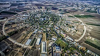
עברית: נהלל (תוכנית קאופמן)
English: Nahalal is a moshav in northern Israel. The physical layout of Nahalal, devised by architect Richard Kauffmann, became the pattern for many moshavim established before 1948; it is based on concentric circles, with the public buildings (school, administrative and offices, services, and warehouses) in the center, the homesteads in the innermost circle, the farm buildings in the next, and beyond those, ever-widening circles of gardens and fields.
|
||
| Date | |||
| Source | Own work | ||
| Author | ZeevStein |
| Camera location | | View this and other nearby images on: OpenStreetMap |
|---|
Licensing
I, the copyright holder of this work, hereby publish it under the following license:
This file is licensed under the Creative Commons Attribution-Share Alike 4.0 International license.
- You are free:
- to share – to copy, distribute and transmit the work
- to remix – to adapt the work
- Under the following conditions:
- attribution – You must give appropriate credit, provide a link to the license, and indicate if changes were made. You may do so in any reasonable manner, but not in any way that suggests the licensor endorses you or your use.
- share alike – If you remix, transform, or build upon the material, you must distribute your contributions under the same or compatible license as the original.

|
This image was uploaded as part of Wiki Loves Monuments 2016.
|
 |
|
This image has been assessed using the Quality image guidelines and is considered a Quality image.
|
File history
Click on a date/time to view the file as it appeared at that time.
| Date/Time | Thumbnail | Dimensions | User | Comment | |
|---|---|---|---|---|---|
| current | 21:03, 3 November 2016 | | 3,992 × 2,242 (11.06 MB) | Ynhockey | User sent me a new version without the name at the bottom |
| 19:01, 14 October 2016 |  | 3,992 × 2,242 (11.06 MB) | ZeevStein | User created page with UploadWizard |
File usage
The following pages on the English Wikipedia use this file (pages on other projects are not listed):
Global file usage
The following other wikis use this file:
- Usage on ar.wikipedia.org
- Usage on de.wikipedia.org
- Usage on en.wikivoyage.org
- Usage on eo.wikipedia.org
- Usage on es.wikipedia.org
- Usage on fi.wikipedia.org
- Usage on gl.wikipedia.org
- Usage on he.wikipedia.org
- משתמש:Eitheladar
- נהלל
- ריכרד קאופמן
- ויקיפדיה:תיבת משתמש/פרטים אישיים
- משתמש:Inon/טבלת תיבות משתמש
- משתמש:מושבניק
- תבנית:משתמש תושב מושב
- משתמש:אור
- משתמש:Deus Ex Machina~hewiki
- משתמש:זיו ארזי
- משתמש:Amitai180
- משתמש:Helios~hewiki
- משתמש:Orlusai
- משתמש:אלעדר
- משתמש:אברהם לינקולן
- משתמש:Ruch
- משתמש:Ofrimadar
- משתמש:שנוזיהו
- משתמש:מחונן פסח
- משתמש:Netneta
- משתמש:Finklez
- משתמש:מתן127/תיבות משתמש
- משתמש:סאבינה
- משתמש:Rimon98
- משתמשת:Zahavas
- משתמשת:PMATAS
- ויקיפדיה:מיזמי ויקיפדיה/ויקיפדיה אוהבת אתרי מורשת/מבוא/ללא לשוניות/תחרות 2012
- ויקיפדיה:מיזמי ויקיפדיה/ויקיפדיה אוהבת אתרי מורשת/ארכיון/תחרות 2012
- משתמש:Levanagr56
- ויקיפדיה:מיזמי ויקיפדיה/ויקיפדיה אוהבת אתרי מורשת/זוכי התחרות בישראל 2012
- משתמש:שיר
- משתמשת:יעל.גולדי
- ויקיפדיה:תמונה מומלצת/המלצות קודמות/מרץ 2017
- ויקיפדיה:תמונה מומלצת/הוספה למומלצים/ארכיון 96
- תבנית:תמונה מומלצת 27 במרץ 2017
- ויקיפדיה:מפגשים/מפגשי עורכים/שיבוץ תמונות WLM - שנת 2016/תמונות ששובצו
- ויקיפדיה:הידעת?/מינואר 2017
- משתמש:דוד עוזר
- ויקיפדיה:מיזמי ויקיפדיה/ויקיפדיה אוהבת אתרי מורשת/ארכיון/תחרות 2017
- ויקיפדיה:מיזמי ויקיפדיה/ויקיפדיה אוהבת אתרי מורשת/זוכי התחרות בישראל/תחרות 2017
- מושבים בישראל
- ויקיפדיה:מיזמי ויקיפדיה/ויקיפדיה אוהבת אתרי מורשת/תחרות צילומים/ארכיון/תחרות 2020
- ויקיפדיה:מיזמי ויקיפדיה/ויקיפדיה אוהבת אתרי מורשת/זוכי התחרות בישראל 2020
View more global usage of this file.