
Deadvlei

Deadvlei is a white clay pan located near the more famous salt pan of Sossusvlei, in a valley between the dunes in the Namib-Naukluft Park in Namibia. Also written DeadVlei or Dead Vlei, its name means "dead marsh" (from English dead, and Afrikaans vlei, meaning lake or marsh). The pan also is referred to as "Dooie Vlei" which is the Afrikaans name. There are many references to the site on the Internet, its name often being translated erroneously in terms such as "dead valley"; a vlei is not a valley (which in Afrikaans is "vallei").[1] Nor is the site a valley; the pan is a desiccated vlei.
Dead Vlei has been claimed to be surrounded by the highest sand dunes in the world, the highest reaching 300–400 meters (350m on average), named "Big Daddy" or "Crazy Dune", resting on a sandstone terrace.
The clay pan was formed after rainfall, when the Tsauchab river flooded, creating temporary shallow pools where the abundance of water allowed camel thorn trees to grow. When the climate changed, drought hit the area, and sand dunes encroached on the pan, which blocked the river from the area.
The trees died as there was no longer enough water to survive. However, some species of plants remain, such as salsola and clumps of nara, adapted to surviving off the morning mist and very rare rainfall. The remaining skeletons of the trees, which are believed to have died 600–700 years ago (ca. 1340-1430), are now black and scorched by the intense heat.[2][3] Though not petrified, the wood has not decomposed because the area is so dry.[4]
Films partly shot there include The Cell, The Fall, Ghajini and Ayan.
Gallery[edit]
-
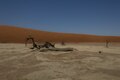
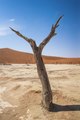
 A dried out camel thorn (Vachellia erioloba) in Deadvlei.
 -
 Deadvlei early in the morning before most visitors start arriving.
 -
 The parched ground in Deadvlei.
 -
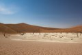
 General view of Deadvlei.
 -
 Aerial view of Deadvlei (2017).
 -
 General view of Dead Vlei
 -
 General view of Dead Vlei
 -
 General view of Dead Vlei
 -
 General view of Dead Vlei
 -
 General view of Dead Vlei
 -
 General view of Dead Vlei
 -
 General view of Dead Vlei
 -
 Road to Dead Vlei


References[edit]
- ^ Bosman, D. B.; Van der Merwe I. W. & Hiemstra, L. W. (1984). Tweetalige Woordeboek Afrikaans-Engels. Tafelberg-uitgewers. ISBN 0-624-00533-X.
- ^ Lancaster, Nicholas (2002). "How dry was dry?—Late Pleistocene palaeoclimates in the Namib Desert". Quaternary Science Reviews. 21 (7): 769–82. doi:10.1016/S0277-3791(01)00126-3.
- ^ Brook, G. A., P. Srivastava, and E. Marais (2006), Characteristics and OSL minimum ages of relict fluvial deposits near Sossus Vlei, Tsauchab River, Namibia, and a regional climate record for the last 30 ka, Journal of Quaternary Science, 21(4), 347-362, doi:10.1002/jqs.977
- ^ Bridgeford, P & M (2006). Touring Sesriem and Sossusvlei. Walvis Bay, Namibia: P & M Bridgeford. ISBN 99916-30-77-5.
Resources[edit]
Further reading[edit]
- Lancaster, Nicholas (2002). "How dry was dry?—Late Pleistocene palaeoclimates in the Namib Desert". Quaternary Science Reviews. 21 (7): 769–82. doi:10.1016/S0277-3791(01)00126-3.
- P & M Bridgeford, Touring Sossusvlei and Sesriem. ISBN 99916-30-77-5
24°45′35″S 15°17′31″E / 24.75972°S 15.29194°E